Lewis & Clark Country
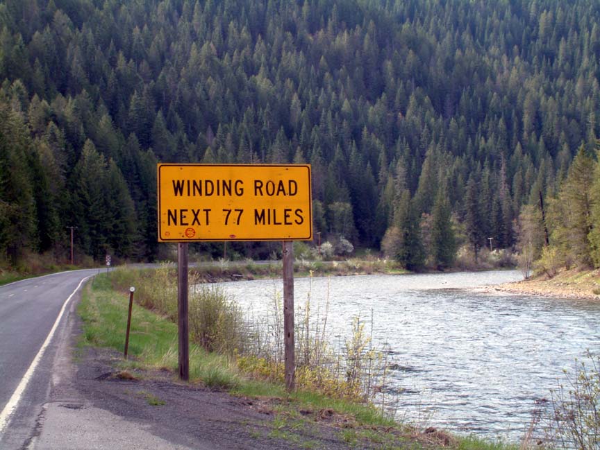
Wow! Where has the time gone - seems like I just updated this blog & today I realized that it's been over three weeks. We've been busy exploring the area, working at the visitor center, and helping out by doing projects for the refuge staff. One of the area's big events this year is the celebration of the "Corps of Discovery", the Lewis and Clark expedition. This year marks the 200-year history of the expedition, which passed through the Bitterroot valley on both the westbound and return legs. Although the exact route through the mountains to Idaho is a 2 to 5 day trek on a very rough 1930s Jeep road, today's highway 12 closely parallels the route for over 120 miles without any towns or private homes along the way. While the two-lane highway is in great shape, it's forced to follow the river canyons and as a result there's a bit of an intimidating sign get you in the right frame of mind.  At the Montana/Idaho border is Lolo pass, which at over 5200' still has 3-foot snow drifts. Crossing into Idaho, the road begins a descent that covers 60 miles and follows the Lochsa river to its end at the Clearwater river near Kooskia. 20 miles from Lolo pass, a ranger station and lodge provide the only gas and food along the trip (www.lochsalodge.com). A great place to stop for lunch and give Brenda a chance to shop for trinkets; although a search for moose (Brenda is still looking for her first moose sighting) was limited to the stuffed moose head on the lodge wall. Back on the road, we stopped to stretch and watch some kayakers and rafters - do those people know how cold that water is?
 Finally we began to exit the mountains and arrived at Kooskia (pronounced "kooz-kee") which was a bit of a disappointment - a small town, slightly worn, and held together by bars and cigarette smoke. We stopped for an ice cream at the local drug /dry goods/trinket/soda shop and in talking to the nice lady learned that it reaches 110+ in the summer. One of the places we had applied to last year was the national fish hatchery located just outside of town; with the heat, no cell phone service, and almost non-existent services we're glad they never called. After topping off the jeep, we headed back the still-winding road to Stevensville. Just before reaching the town of Lolo at the highway 93 intersection we stopped at Fort Fizzle, a unique historic site.
  In 1877 800 Nez Perce, led by Chief Looking Glass, left their homes in western Idaho rather than be restricted to a reservation. As they crossed the Bitterroots, the local militia, augmented by volunteers, built fortifications across a narrow portion of the canyon to stop the Nez Perce until the pursuing Army could arrive. The Nez Perce met with the soldiers who told them they could not pass and that they must surrender. The Nez Perce returned to their camp, and early the next morning rode up the ridgeline and around the soldiers and on to the valley without a shop being fired. Hence the name "Fort Fizzle". Until next time, thanks for tuning in!
 At the Montana/Idaho border is Lolo pass, which at over 5200' still has 3-foot snow drifts. Crossing into Idaho, the road begins a descent that covers 60 miles and follows the Lochsa river to its end at the Clearwater river near Kooskia. 20 miles from Lolo pass, a ranger station and lodge provide the only gas and food along the trip (www.lochsalodge.com). A great place to stop for lunch and give Brenda a chance to shop for trinkets; although a search for moose (Brenda is still looking for her first moose sighting) was limited to the stuffed moose head on the lodge wall. Back on the road, we stopped to stretch and watch some kayakers and rafters - do those people know how cold that water is?
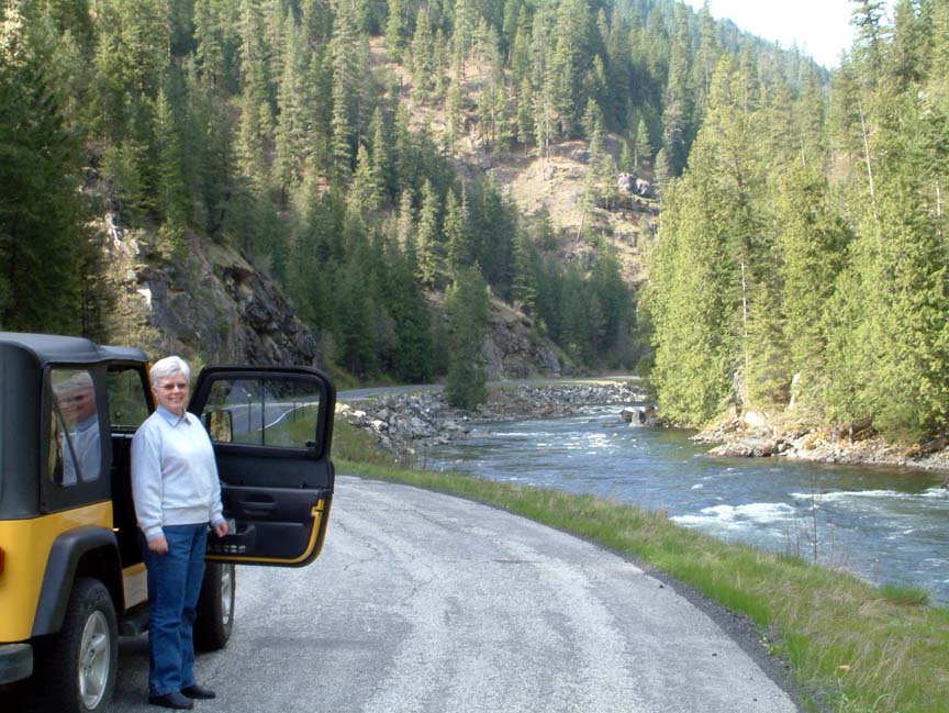
 Finally we began to exit the mountains and arrived at Kooskia (pronounced "kooz-kee") which was a bit of a disappointment - a small town, slightly worn, and held together by bars and cigarette smoke. We stopped for an ice cream at the local drug /dry goods/trinket/soda shop and in talking to the nice lady learned that it reaches 110+ in the summer. One of the places we had applied to last year was the national fish hatchery located just outside of town; with the heat, no cell phone service, and almost non-existent services we're glad they never called. After topping off the jeep, we headed back the still-winding road to Stevensville. Just before reaching the town of Lolo at the highway 93 intersection we stopped at Fort Fizzle, a unique historic site.
 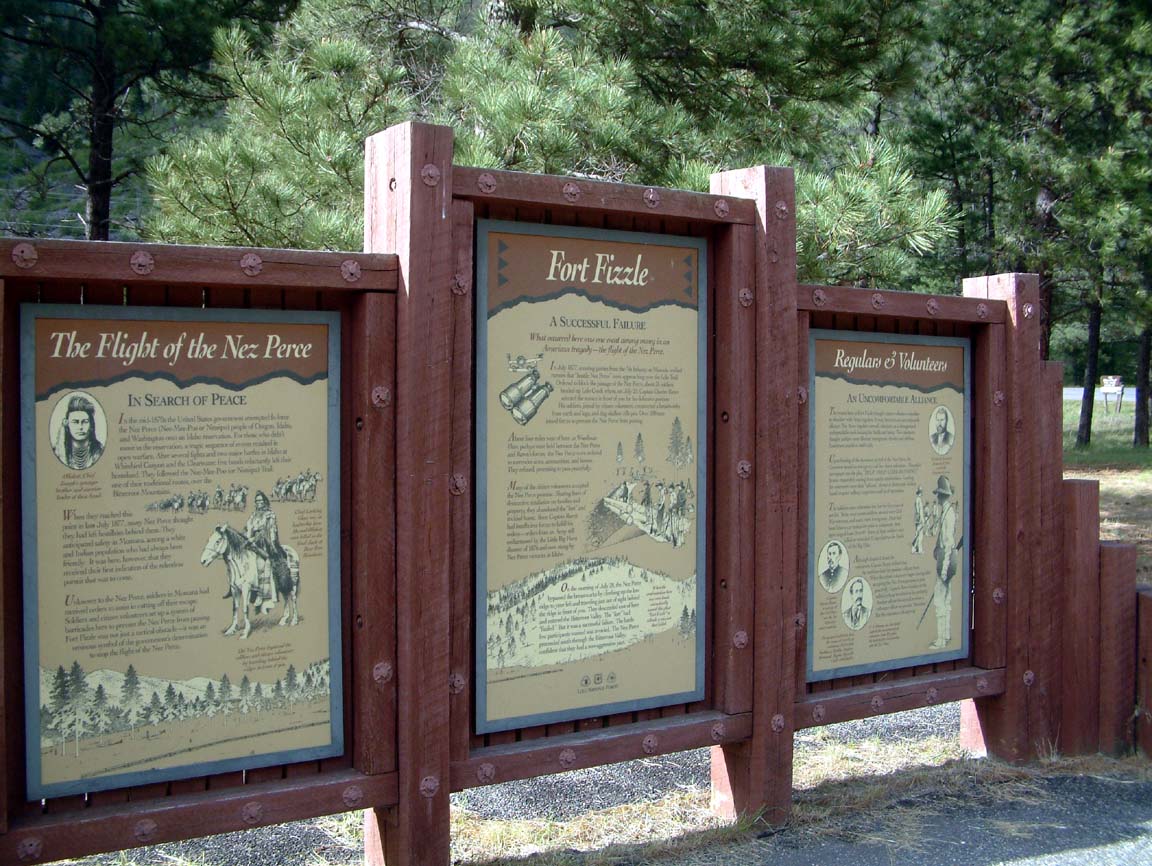 In 1877 800 Nez Perce, led by Chief Looking Glass, left their homes in western Idaho rather than be restricted to a reservation. As they crossed the Bitterroots, the local militia, augmented by volunteers, built fortifications across a narrow portion of the canyon to stop the Nez Perce until the pursuing Army could arrive. The Nez Perce met with the soldiers who told them they could not pass and that they must surrender. The Nez Perce returned to their camp, and early the next morning rode up the ridgeline and around the soldiers and on to the valley without a shop being fired. Hence the name "Fort Fizzle". Until next time, thanks for tuning in!