This winter we’re volunteering at the Desert National Wildlife Refuge just outside Las Vegas, so it was time to say goodbye to the Oregon Coast and hit the road. Before we left, we enjoyed a walk on the beach near Bandon during a sunny, warm day. It was shortly after a major storm, and the beach was littered with interesting stuff that the waves and tide had washed ashore. There were piles of what looked like the innards of a large space alien. 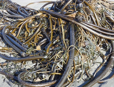 Or it could be kelp. But that would be boring so we prefer to think of them as alien innards. We suspect that their spaceships were brought down by the chemtrails from airliners. It must be true because we read about it on Facebook.
There’s something about a walk on the beach that rejuvenates the spirit. The crashing waves, screaming gulls, and bright sun always lift our spirits.
Or it could be kelp. But that would be boring so we prefer to think of them as alien innards. We suspect that their spaceships were brought down by the chemtrails from airliners. It must be true because we read about it on Facebook.
There’s something about a walk on the beach that rejuvenates the spirit. The crashing waves, screaming gulls, and bright sun always lift our spirits. Stocked up with frozen organic Blueberries and jars of Marionberry jam, we headed down I-5. After a stop for annual motor home maintenance, we crossed over the mountains at Bakersfield and turned north up the east side of the Sierras to one of our favorite stops, Lone Pine, California.
Outside of Lone Pine, the Alabama Hills and the Sierras have been the filming location of hundreds of movies and television series. Most of my childhood favorites; The Lone Ranger, The Cisco Kid, Roy Rogers, and many others were filmed here. This area also filled in for India for the movies “Gunga Din” and “Lives of the Bengal Lancers,” among others. Driving through the Alabama Hills, with Mount Whitney in the distance, it’s easy to imagine the Lone Ranger and Tonto riding down the road, or one of the “Graboids” from the movie “Tremors” popping up.
Stocked up with frozen organic Blueberries and jars of Marionberry jam, we headed down I-5. After a stop for annual motor home maintenance, we crossed over the mountains at Bakersfield and turned north up the east side of the Sierras to one of our favorite stops, Lone Pine, California.
Outside of Lone Pine, the Alabama Hills and the Sierras have been the filming location of hundreds of movies and television series. Most of my childhood favorites; The Lone Ranger, The Cisco Kid, Roy Rogers, and many others were filmed here. This area also filled in for India for the movies “Gunga Din” and “Lives of the Bengal Lancers,” among others. Driving through the Alabama Hills, with Mount Whitney in the distance, it’s easy to imagine the Lone Ranger and Tonto riding down the road, or one of the “Graboids” from the movie “Tremors” popping up.  There aren’t many trees, but this Cottonwood was a spectacular spot of color:
 Just west of the Alabama Hills, the view opened up with this spectacular vista:
 We’re always interested in finding film locations and “Gunga Din”, filmed her
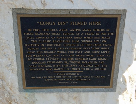 e in the late 30’s, is one of the classics we always enjoy. So off we went to find some of the sites where filming took place. We found the area where the English army is about to be ambushed; there’s a monument describing the movie and nearby is the “Khyber Pass”.
  But our favorite location is the site where Cary Grant and Sam Jaffe, accompanied by their elephant, start to cross a suspension bridge over a huge chasm. In the movie, they panic
  when the elephant tries to follow them across the bridge. In an era well before computer-generated graphics, it’s amazing to see how realistic the chasm is – because the bridge is only about six feet above the ground. We found the site where the scene was filmed; the rocks still have remnants of the bridge support and ramp that was used for the elephant. In fact, along with a van, we parked in the “chasm”!
 Taking a break from exploring, we visited the Lone Pine Film History Museum, a place packed with memorabilia and information. Clothing worn by John Wayne, Roy Rogers, and cast members of many movies and TV shows are on display; there’s even the actual car that Humphrey Bogart drove in the movie “High Sierra”.
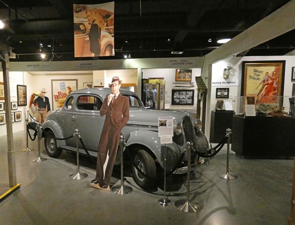 Some of the more recent movie props are also here. Brenda made friends with a “Graboid” and “Assblaster” from the movie “Tremors”.
 Finally, we drove the road up into the mountains and to Whitney Portal, the film site for “High Sierra” and the jumping off point for hikers climbing Mount Whitney. It is impossible to describe the beauty, so I won’t try.
 We’ve arrived at our winter home and are getting settled in – we’ll be back with an update soon!
 We’re staying at the El Centro Naval Air Facility, just a few miles from the town of El Centro, in the Imperial Valley of Southern California. If you’ve eaten lettuce recently, chances are it came from this area. Also broccoli, cauliflower, and carrots. The amount of agriculture here is astounding! A few facts from the Imperial Country Farm Bureau:
 - Two-thirds of the vegetables consumed by Americans during the winter months are grown here.
- Each year’s lettuce crop is enough to make over two billion dinner salads.
- Enough carrots are grown here each year to provide a four-ounce serving to over five billion people.
- Two-thirds of the vegetables consumed by Americans during the winter months are grown here.
- Each year’s lettuce crop is enough to make over two billion dinner salads.
- Enough carrots are grown here each year to provide a four-ounce serving to over five billion people.
 - Almost two million tons of hay are harvested and sent to California Dairies and overseas locations each year. With the weather and irrigation, fields can provide nine to ten cuttings a year, compared to three or four elsewhere.
Driving throughout the area, every inch is covered with some type of crop. Farm machinery is everywhere, and the planting and harvesting follows a well-choreographed plan. Each day, thousands of workers from Mexicali line up at the border to load on contracted old white school busses for their trip to the fields. The workers, holding “worker” visas, move through the fields picking the produce and throwing it up onto conveyer where it’s washed, bagged and placed in crates for shipment. Not surprisingly, unemployment in the area runs well over 25%, because even through field jobs are available, not many American citizens will work the fields for minimum wage.
- Almost two million tons of hay are harvested and sent to California Dairies and overseas locations each year. With the weather and irrigation, fields can provide nine to ten cuttings a year, compared to three or four elsewhere.
Driving throughout the area, every inch is covered with some type of crop. Farm machinery is everywhere, and the planting and harvesting follows a well-choreographed plan. Each day, thousands of workers from Mexicali line up at the border to load on contracted old white school busses for their trip to the fields. The workers, holding “worker” visas, move through the fields picking the produce and throwing it up onto conveyer where it’s washed, bagged and placed in crates for shipment. Not surprisingly, unemployment in the area runs well over 25%, because even through field jobs are available, not many American citizens will work the fields for minimum wage.
 We have a great spot in the base campground which hosts a number of retired military “snowbirds”. The base itself is small, but busy with jets practicing simulated carrier
 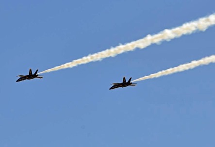 landings and the training of the Blue Angels acrobatic team. It’s a noisy place from early morning to 10 O’clock at night, and our cat is not happy.

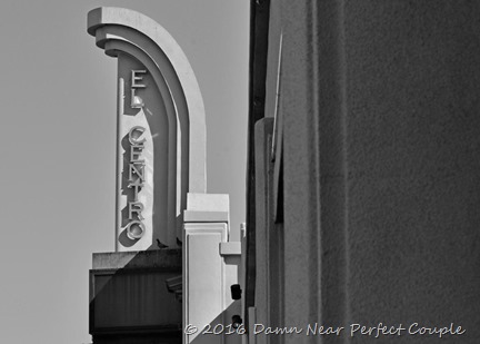 The town of El Centro, about eight miles away, is a typical town found in an agricultural area. Dusty, time-worn, with poor neighborho
 ods and a Mexican food restaurant on every corner – our map program shows 64 within a ten-mile radius! Like so many of these towns, the downtown area is largely abandoned, but
  enough of the old buildings remain to be able to imagine how it must have looked in it’s prime. I thought these images conveyed the dusty, treeless downtown area when shown in black and white – but truthfully, there’s not much of a difference in color.
 It’s an unusual feeling to be living well below sea level. Thankfully, there’s a large mountain range to our west to keep out the ocean, at least until “the big one”. Traveling
  north of town, a sugar beet factory has even painted the elevation on their building. Further north toward the Salton Sea in the little town of Calipatria, we visited their famed flag pole, which at 184 feet tall is a visible indicator of just far below sea level they are.
 Farther north, we explored the west side of the Salton Sea, California’s largest lake that wasn’t supposed to be. It was created by a unintentional break in a diversion canal of the Colorado River in 1905. Up until the early 70s, the lake was a popular place for fishing, boating, and became a popular resort with many seaside communities.
 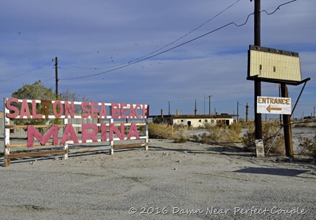 But the lack of freshwater flowing into the lake, the runoff of agricultural fertilizers, and evaporation have left the lake with high salinity, few fish, and abandoned homes. We took a drive through what was the resort community of Salton Beach, now a mostly deserted ghost town. If you want to see what a community would look like after the Zombie apocalypse, this is the place to go. About the only thing we say moving were the gulls and shorebirds, along with plastic trash bags blowing in the wind.
  We’ll be taking a trip to the east side of the lake soon, so check back and see what we’ve been up to!
For us anyway, was the area of Northern California that lies just south of Klamath Falls, Oregon. As we left the coast this year, we decided to take a different route down to Reno, so we left I-5 at Medford and drove east to Klamath Falls. Once there, we headed south, crossing into California just south of town and into the town of Tulelake. In our travels, we’ve seen towns where parents, frustrated with the antics of their teenagers, gather together to vent their anger by giving the high school teams an embarrassing name. We first saw this phenomenon in Tillamook, Oregon, where when entering the town you see the high school building with large letters that say “Tillamook High School – Home of the Cheesemakers!”  Apparently that same frustration existed in this small town, as we were greeted with this sign on entering town. I had to wonder if the girls teams were known as the “Lady Honkers”….and is the Junior Varsity the “Quackers”?

OK, enough of that.
We spent a couple of days in the one-store town of Tionesta, population 30, at a nice little park called the Hawk’s Nest. From there we drove to Lower Klamath Falls National Wildlife Refuge, established in 1908 as the nation’s first migratory bird refuge. Over 80 percent of the Pacific Flyway’s migratory waterfowl stop here, and the 50,000 plus acres of lakes and marsh attract thousands of ducks, pelicans, and birds. Although we visited during the early part of the migration, the lakes were covered in Coots, Grebes, White Pelicans, and a variety of ducks:
We watched as the White Pelicans, surrounded by Grebes and Coots, gathered in a group to drive fish into the shallows:
We enjoyed the refuge, but were fascinated by the Lava Beds National Monument, a place we’d never heard of.  Covering over 46,000 acres, the monument is a beautiful area of lava flows, canyons, and lush desert. Two things made this place special for us; history and caves. The history of the area is extensive, but we were especially interested in the Modoc Indian Wars that took place here. Briefly, during the winter of 1882-83, a small band of Modoc Indians led by Keintpoos, known as “Captain Jack” refused to remain on the reservation and entrenched themselves in the lava beds. Scattered fighting ensued until in January 1873 when the Army attacked the Modocs in force. Fighting in fog, cold, and the confusing terrain of the lava beds, the Army, defeated, gave up the fight. This was followed by a number of meetings between Captain Jack and the Army, led by Brigadier General E.R.S. Canby, a Civil War veteran. No progress was made, and the Modocs, believing that if they killed the enemy leader the Army would give up, ambushed the General at a meeting, killing him. General Canby was the first general killed in the Indian wars, and as a result, the Army ordered an additional 1000 troops into the area. Eventually Captain Jack was captured, and he was convicted of murder and hung in October 1873.
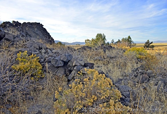
 Walking the trail through the area where the battles took place it’s easy to see how difficult it was to find and dislodge the Modocs. The broken lava provided nooks, crannies, and natural fighting positions, many of which are still visible today. Although it’s an area of rock and desert, it’s still a beautiful place to stroll.
 A bit down the road, we came to the site of General Canby’s murder and a replica of the original marker:
 The other fascinating thing about this area is the caves – nearly 800 have been mapped. These are lava tube caves – some are large and developed with trails, some are “ice caves” that contain ice year around, and others run the gamut from easily accessible to those that require scrambling on hands and knees. What we found remarkable is the open access – just visit the interpretive center, answer questions to be screened for white-nosed syndrome, check out a helmet and flashlight if you like, then go caving. You’re on your own, a remarkable approach to exploring a cave these days.
We normally think of lava beds are pretty desolate; but driving through the monument provided some truly beautifully vistas:
The other fascinating thing about this area is the caves – nearly 800 have been mapped. These are lava tube caves – some are large and developed with trails, some are “ice caves” that contain ice year around, and others run the gamut from easily accessible to those that require scrambling on hands and knees. What we found remarkable is the open access – just visit the interpretive center, answer questions to be screened for white-nosed syndrome, check out a helmet and flashlight if you like, then go caving. You’re on your own, a remarkable approach to exploring a cave these days.
We normally think of lava beds are pretty desolate; but driving through the monument provided some truly beautifully vistas:
 Finally, as we drove through the area, we came across this remarkably healthy looking coyote. It’s not often we have the opportunity to see such a beautiful animal, and it seemed to enjoy the attention: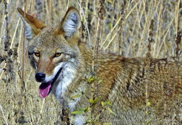
 We’ve made it back to Benson, AZ and the Escapees park where we’ll be spending the winter months. We still have more travel to catch up on, so look for another blog soon!
Between Lone Pine and the Sierras are the Alabama Hills, a line of rock formations that are unique; we’ve never seen anything like them anywhere else. Driving along “Movie Flat Road”, you expect to see the Lone Ranger and Tonto around every turn – so many westerns were filmed here. Surprisingly, there is nothing left of any movie site, since the area is BLM land, everything must be returned to it’s natural state after filming. It’s a shame in a way, imagine being able to roam the streets of a wild west town, the golden temple of Gunga Din, or the streets of Perfection in the movie Tremors! But even without the sets, the Alabama Hills are amazing - lots of side roads into the rocks, hiking trails everywhere, and best of all, fabulous views of the rocks with the Sierras and Mount Whitney in the background. One formation we saw could be called the “heart” of the Alabama Hills (below).

 We traveled north one afternoon to the small town of Independence and visited the Mount Whitney Historic Fish Hatchery, an interesting and beautifully maintained state facility built in the 1940’s using 3400 tons of native granite. Although it’s not active now, it’s maintained for visitors, and like the hatchery we volunteered at this year, had a large pond of “display” trout to view.
 On another day, we drove east for a day visit to Death Valley. It’s an interesting day when you can start by looking at the highest point in the continental US (Mt Whitney 14,405’), then drive to the lowest point (-287’). We visited Death Valley in the late 70s while living in Las Vegas and remember asking ourselves “what’s the attraction"? After all they don’t call it “nice to look at” valley, or even “moderately pleasant” valley…..it’s DEATH valley! And there’s a reason for that. Miles and miles of rock, sand, and scrub brush, a place where even the snakes carry canteens. But we made the trip, stopped at the Furnace Creek (another great descriptive name), visitor center, then turned around and headed back home…..asking ourselves why did we drive all that way? I’m sure there are plenty of people who love Death Valley, but for us, we’ve permanently crossed it off our bucket list.
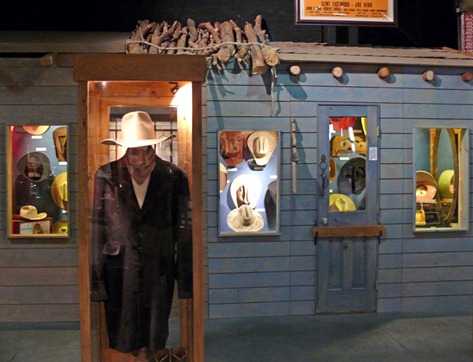
 No visit to Lone Pine would be complete without a stop at the Museum of Film History, a wonderful collection of all things filmed in the area. As “Boomers”, it’s a reminder of our younger years spent waiting for Saturday morning and Hopalong Cassidy, Gene Autrey, and of course, Roy Rogers. Old posters, TV clips, and memorabilia like the “cowboy hat hall of fame” bring back old memories, and there is an extensive collection of props used in newer movies also. We enjoyed the movie “Tremors” and Brenda made friends with one of the movie’s “Graboids”. At the entrance, we marveled over the custom Cadillac of Nudie Cohn, the man who put the rhinestones on cowboy suits. He must have been very successful judging by the “Nudiemobile”, covered with real silver dollars and other uh, stuff. We thoroughly enjoyed our visit to this museum, and recommend it to all.

 We left Lone Pine with a promise to ourselves that we’d return again, perhaps next time in the spring or early fall when it’s a bit warmer. Back on Highway 395, we headed south for a stay at Edwards Air Force Base. I’ve visited Edwards many times in my working life, and it’s a bit easier to take, although not much, visiting it as a retiree. Edwards is the Flight Test Center for the Air Force, and if you wanted to pick a place where a failed test aircraft could fall out of the sky and not damage anything, this is the perfect place. Think Death Valley with a runway. But it has a nice Famcamp, a good commissary, and is the only decent place in the area to spend a night. We took a tour around the base, past the Test Pilot School and into the NASA area where we saw the two Space Shuttle carriers, now without a mission, parked on the ramp. From a distance, they look like regular Boeing 747s, but if you look close, you’ll see twin tails that were needed since the Shuttle blocked the airflow over the normal tail. Next to the aircraft is the shuttle mating facility, where they would lift the shuttle onto the back of the 747.

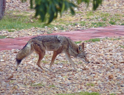
 The base Famcamp has good facilities, and there aren’t many rodents thanks to the pretty camp coyote that paid us a visit:
 We’re on our way to the San Clemente area for a stay at Camp Pendleton’s San Onofre campground and a Thanksgiving visit with our daughter and her husband. After that, we’ll be traveling back to Texas for our winter stay. We may not have anything interesting for a while, but don’t go away, we’ll be back! For all of our readers, Brenda and I wish you all a happy Thanksgiving Holiday!


