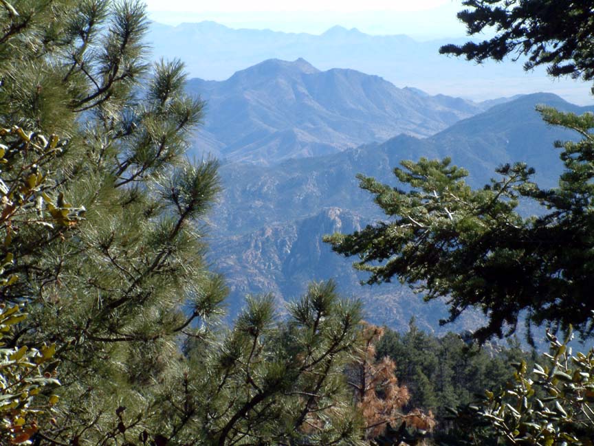
It's amazing how busy you can become when you're not distracted by having to work for a living. Brenda and I have been exploring the mountains, seeing old and new with friends, and visiting the tourist attractions like Tombstone, and suddenly it's been two weeks since I updated the blog. The past two weeks have been windy at times but still warm without any measurable rain, and we've been able to visit two of our favorite mountain ranges, the Pinalenos and the Chiricahuas, referred to as the "sky islands" because they provide forests and streams in the midst of the desert.  The Pinalenos, located just west of Safford, Arizona are the tallest in southern Arizona, with Mount Graham topping 10,000 feet. A 37-mile road, mostly paved, ends at a beautiful campground and trout lake, a place we camped frequently when we were stationed here. Because of the drought, we were able to drive 25 miles up the mountain without encountering any snow, but the road beyond that was blocked by the Forest Service for the winter. Still, the scenery was amazing from the 9600' level and the view of the desert over a mile below memorable, although Brenda wasn't crazy about the absence of guardrails. The Chiricahuas, in extreme southeast Arizona, are called the "Gallapagos of America" because they are at the center of two deserts and two mountain ranges, and contain a huge variety of wildlife, especially birds. Some of the most unusual areas of rock formations you'll ever see are here, primarily in the little-known Chiricahua National Monument.
  We hiked the 3.5 mile Echo Canyon loop, which somehow is all uphill, and were amazed at the balancing rocks - this area must have been the inspiration for the "Roadrunner" cartoons.
 Although the Apache tribes inhabited the area, the area of where the monument is located was avoided because it was thought inhabited by spirits; a fear easy to understand, the place is really spooky. An intriguing formation is Chochise Head, which Apache legend says wasn't there until the day after Cochise died. The formation is the profile, complete with headdress, and if you look close, you can even see a lone tree which forms an eyelash.
 Besides the monument area, there is an 87,000 acre wilderness area and additional acres of national forest. We drove a dirt road across the mountain range, taking a side trip to a campground at 8500' (and in the snow), and eventually wound up on the eastern side in Cave Creek Canyon, a nationally-known "birding" area. While I'd just as soon watch mud harden as watch birds, it's interesting that over half of the North American bird species can be found here, especially hummingbirds. Aside of the bird thing, the area is stunning, with huge vermillian rock walls and sycamore-lined creeks.
 We'd like to stay in this area next winter as it provides close access to the heart of the mountains. The only drawback is that the nearest town is Rodeo, NM, population 200, and the nearest grocery (and restaurant) is in Douglas, AZ, 65 miles south. Besides these trips, we traveled 70 miles of dirt roads through rolling grasslands to the ghost town of Lochiel, AZ on the Mexican border, had a disappointing trip to Tombstone, toured and sampled winerys, visited Fort Huachuca's PX, and hiked an amazingly beautiful trail (all uphill again) near Fort Grant. We'll be leaving this area on the 1st of March, bound for southern California for a visit with our daughter and future son-in-law. Plus I want to show Brenda Edwards AFB so she can understand the intense pain I went through having to spend 10 days there every two years during evaluation visits. After that, we're off along the California/Oregon coast for a while....or maybe not. We'll figure it out as we go. Thanks for checking on us and feel free to leave a comment.
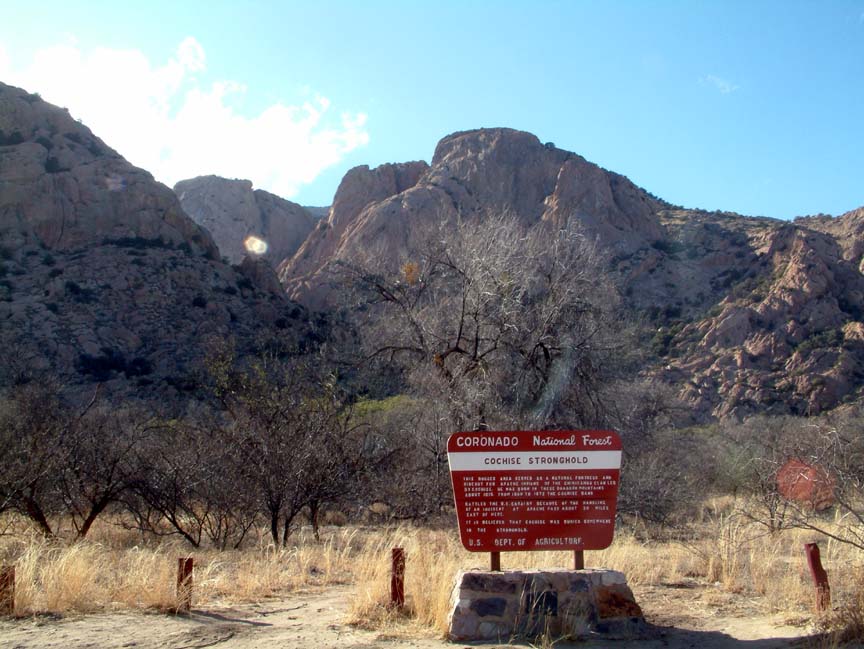
 Southeastern Arizona was the home of Cochise, and this week we explored areas that he and the Chiricahua Apache lived and fought. Our first trip was to the Cochise Stronghold in the Dragoon mountains (www.cochisestronghold.com), where Cochise and his 1000 of his followers lived for 15 years, and where Cochise is reputed to be buried in a secret location. After a short drive on gravel roads we came to a beautiful campground where a three mile trail to the Stronghold began. It was a warm day, sunny with temperatures in the low 70s.
  T
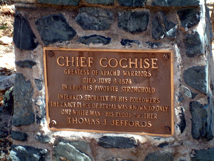
T he trail began with an uphill climb, and continued to climb through the canyon over a rocky surface. It was easy to see why Cochise and his tribe made this area their home; from the high peaks sentries could see for miles across the barren valleys and the terrain would be virtually impenetrable by an enemy. The trail climbed though pinion pine and live oak and eventually we came to a small water pool known as Cochise Spring. Because of the long drought, the spring was barely a trickle, but provided a cool and shady area to rest. While taking our break, the sky darkened and the wind began to howl down the canyon. Although the possibility of rain was slight, the temperature was dropping rapidly and we decided to return to the campground. Although we didn't complete the hike, it was a thoroughly enjoyable day in an incredibly beautiful area.
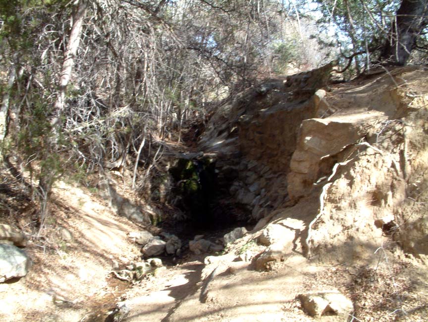
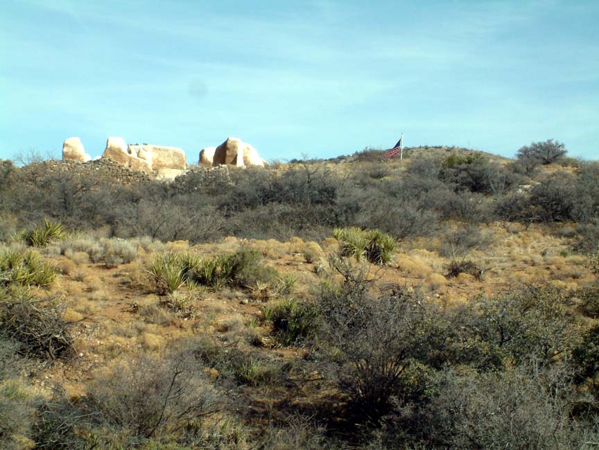
Our next trip was to a truly interesting site, the Fort Bowie National Historic Site (www.nps.gov/fobo/), the only national historic site which requires a 1.5 mile hike to reach. Built in 1868, the fort was built to protect the Butterfield stage line and settlers from Chiricahua Apache and other Indian tribes, and replaced an earlier, less substantial fort. The National Park Service has done a remarkable job in preserving the ruins and surrounding area, which only were acquired in 1964. A well-maintained trail with little elevation change except for the overlook loop portion provides beautiful views.  The trail crosses the stage road and the remains of the stage stop, the fort cemetery, and Apache Spring, a vital source of year-around water and the reason that the stage route and fort were constructed.
  Hiking with friends, we passed the cemetery, stage stop, and came to Apache Spring.
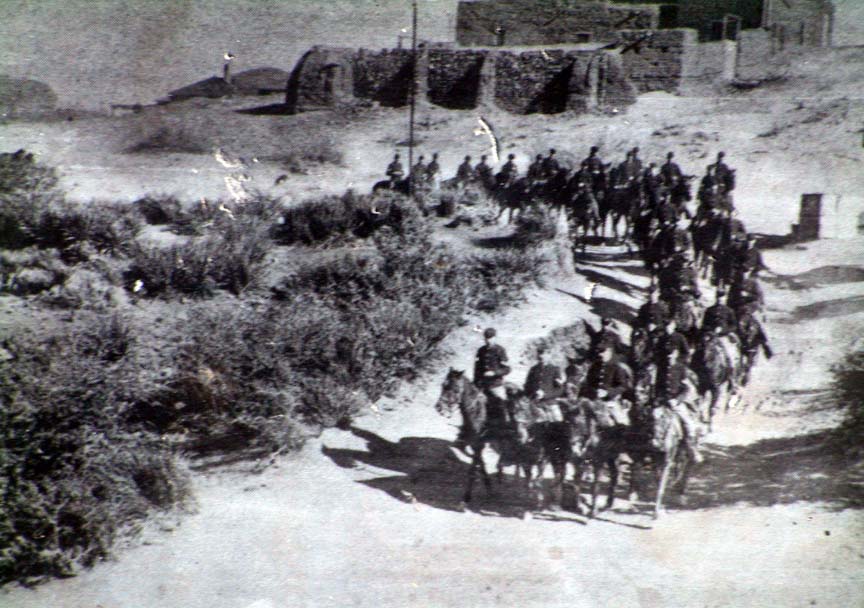
 The spring, which still produces a small water flow, was the site of the Battle of Apache Pass, when in 1862 a large force of Chiricahua Apache under Cochise fought a two-day battle with a Union force enroute to confront Confederate troops in New Mexico. Photos and archeological maps at the visitor center allow you to see where the battle took place, and the trail is close enough to the areas to let you walk the actual battle site. Just below the entrance of the fort, an actual photograph of troopers leaving the fort is posted with today's ruins in the background. It's a unique opportunity to compare what the fort looked like as opposed to what remains today; here is the same view from the trail:
 It's hard to imagine the hardships that soldiers and their families endured living in these times and harsh locations. This was an enlightening visit to a unique national monument and shouldn't be missed if you have the opportunity. One last note; don't believe the little lady volunteer at the visitor center when she tells you that the Overlook Trail loop back to the main trail is easy. It climbs high above the fort, then drops quickly with switchback after switchback. The view is worth it, now that I've hea
led.
 The Pinalenos, located just west of Safford, Arizona are the tallest in southern Arizona, with Mount Graham topping 10,000 feet. A 37-mile road, mostly paved, ends at a beautiful campground and trout lake, a place we camped frequently when we were stationed here. Because of the drought, we were able to drive 25 miles up the mountain without encountering any snow, but the road beyond that was blocked by the Forest Service for the winter. Still, the scenery was amazing from the 9600' level and the view of the desert over a mile below memorable, although Brenda wasn't crazy about the absence of guardrails. The Chiricahuas, in extreme southeast Arizona, are called the "Gallapagos of America" because they are at the center of two deserts and two mountain ranges, and contain a huge variety of wildlife, especially birds. Some of the most unusual areas of rock formations you'll ever see are here, primarily in the little-known Chiricahua National Monument.
  We hiked the 3.5 mile Echo Canyon loop, which somehow is all uphill, and were amazed at the balancing rocks - this area must have been the inspiration for the "Roadrunner" cartoons.
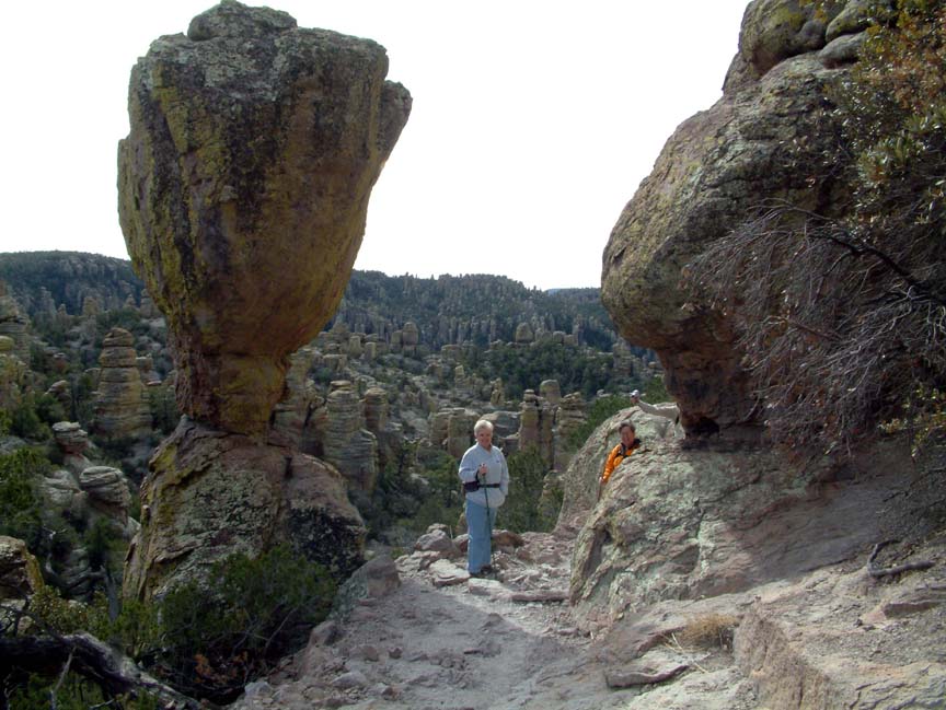 Although the Apache tribes inhabited the area, the area of where the monument is located was avoided because it was thought inhabited by spirits; a fear easy to understand, the place is really spooky. An intriguing formation is Chochise Head, which Apache legend says wasn't there until the day after Cochise died. The formation is the profile, complete with headdress, and if you look close, you can even see a lone tree which forms an eyelash.
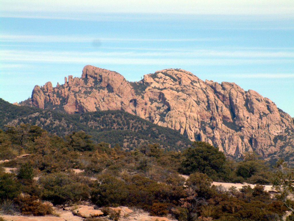 Besides the monument area, there is an 87,000 acre wilderness area and additional acres of national forest. We drove a dirt road across the mountain range, taking a side trip to a campground at 8500' (and in the snow), and eventually wound up on the eastern side in Cave Creek Canyon, a nationally-known "birding" area. While I'd just as soon watch mud harden as watch birds, it's interesting that over half of the North American bird species can be found here, especially hummingbirds. Aside of the bird thing, the area is stunning, with huge vermillian rock walls and sycamore-lined creeks.
 We'd like to stay in this area next winter as it provides close access to the heart of the mountains. The only drawback is that the nearest town is Rodeo, NM, population 200, and the nearest grocery (and restaurant) is in Douglas, AZ, 65 miles south. Besides these trips, we traveled 70 miles of dirt roads through rolling grasslands to the ghost town of Lochiel, AZ on the Mexican border, had a disappointing trip to Tombstone, toured and sampled winerys, visited Fort Huachuca's PX, and hiked an amazingly beautiful trail (all uphill again) near Fort Grant. We'll be leaving this area on the 1st of March, bound for southern California for a visit with our daughter and future son-in-law. Plus I want to show Brenda Edwards AFB so she can understand the intense pain I went through having to spend 10 days there every two years during evaluation visits. After that, we're off along the California/Oregon coast for a while....or maybe not. We'll figure it out as we go. Thanks for checking on us and feel free to leave a comment.