Showing posts with label Oregon. Show all posts

Saturday, July 23, 2022

We're Still Here!

 It has been a long time since I've posted on our blog, and we're still living our dream although we haven't been doing much of anything new.  After a couple of months in the Coos Bay area, we moved south to Brookings, on the California border, for a summer of volunteering for US Fish & Wildlife as Marine Mammal and Bird Interpreters.  We arrived on May 1st, and have settled into a routine of showing visitors the local wildlife and doing a few programs on the weekend.

We're at Harris Beach State Park, a place we've been twice before.  Our last visit in 2017 was memorable; it was the year Brenda had heart surgery and later we had to evacuate due to the threat of a wildfire.  So far this year all our memories are positive!  Our site is surrounded by blackberry bushes, crocosmia flowers, and wax myrtle.  Hummingbirds, mostly Anna's, are frequent visitors to our feeders, so much so that I have to refill our four feeders every other day.  We're also visited on our seed feeder by Song Sparrows, Black-Capped and Chesnutt-Backed Chickadees, and the beautiful but noisy Steller's Jay.  The park furnished us with a beautiful full-hookup site in the trees.  In exchange, we teach the "Junior Ranger" (kids 6-12) on Saturday mornings and have a nature walk and amphitheater program on Friday and Saturday nights. 

Junior Rangers demonstrating the size of a Blue Whale

Harris Beach is a beautiful, tree covered park lush with plants, many of which are still flowering.  All sites are paved and most have full hooks, and many have a view of the ocean.  Each site is separated by hedges and other plants to provide privacy.  The selling point for us is the climate - temperatures in the high 60s and low 70s, with many sunny days.  It hasn't rained since mid-June and probably won't rain again until mid to late September.  Everything remains green, though, thanks to the late night/early morning marine layer that brings in heavy fog.  


This year we discovered a first - a Peregrine Falcon pair had made a nearby rock their home and produced two chicks.  This was the first time in years that they've been seen here, and their presence caused quite a stir among the birding community.  We watched as the chicks rapidly grew; soon they were practicing flying by jumping up and letting the wind keep them aloft.  The parents both brought them food - on one occasion we watched as the adult tore pieces off of a pigeon and fed the chick.  It wasn't long before they fledged, and shortly after they left the area for the summer.  Hopefully they'll be back again next year.

Peregrine Falcon Chick

Chick Being Fed by Adult

 
This year we've been spending time at Arch Rock Viewpoint, about 10 miles north of the park.  It's a beautiful place - Arch Rock is not only interesting to look at but has a number of Pelagic Cormorants on nests.  We've been watching as the chicks have hatched and been fed by the mother.  They grow fast and soon will be flying.  Along the trail to the viewpoint the ground is covered in wild Lilly of the Valley with an occasional wild Iris poking through the Lilly leaves.


We're enjoying our stay here; the weather, although cool on most days, is a wonderful alternative to the 100+ temperatures in most of the nation.  As usual, we're grateful to US Fish & Wildlife for the opportunity and for the great support.  We've met so many great people while showing them the wildlife along the coast.  We'll be here until September 1st when we'll return to the Coos Bay area for annual medical appointments.  We'll be back on our blog soon, so come back and visit!


Friday, September 17, 2021

Eastern Oregon Part II

 We've always been fascinated by ghost towns.  Seeing what remains today and trying to visualize what they looked liked in their heyday is always interesting, especially when you can read the history of the towns and find old photographs.  We read about the town of Cornucopia, an old mining town, and decided to check it out.

On our way east to visit the town, we stopped at the Oregon Trail Visitors Center, a BLM facility that sits next to the trail and has a large interpretive center.  Which, since it is a federal facility, was closed.  We walked along the trail but didn't venture down to the wagon ruts themselves since the temperature was over 90 and the return would be a lengthy uphill walk.  There was little to see without the center being open and the heat was fierce, so we decided to head for Cornucopia.

We followed the highway east from the visitor center as it followed a creek through canyons and desert until reaching the small town of Halfway.  From there, we headed north on a dirt road into Cornucopia. 

Cornucopia sits in a 4700' narrow valley surrounded by steep mountains on three sides.  This is the "backside" of the Wallowa Mountains, a rugged, heavily forested area.  Following the dirt road into the former townsite we saw what has become a typical "ghost town" - fallen remains of buildings, buildings barely standing, and others that have been fully or partially restored and are occupied during the summer.  

Road to Cornucopia

The town was named after a mine opened in 1884 and the successful mining of gold led to a population growth of around 700 residents by 1902.  This was a tough place to live; the alpine environment meant extremely hard winters with snowfall measured in the tens of feet.  Still, the mine continued to operate until 1929 when the stock market crashed, dropping the population to 10.  It had a short revival when more efficient mining equipment was introduced, but WWII was a death knell for the town, and after over $4M in gold was extracted from the many tunnels under the town, the mine shut down.  

Cornucopia Town Site

Navigating over rough gravel and dirt roads, buildings became visible.  Top left is what was probably a miner's dormitory, bottom left is the original jail, to the right a restored and occupied home.


There are many photos available that show the town in the days it was booming:


The winters were long and harsh:


A short distance from the town site is the Cornucopia Lodge and Pack Station, a modern lodge that serves as a starting point for those exploring the Eagle Cap Wilderness and for cross country skiing in the winter. 

Besides lodging, it has a snack bar, large living area with fireplace, and the only WiFi in the area.  We talked to the lady manager who told us that she and her husband live there year around.  During the winter it sometimes resembles living in the lodge from "The Shining" but so far, without the ghosts.  When asked how she could tolerate the snow and cold, she told us that she was from Stanley, ID, reputed to be the coldest town in the lower 48.  We remember visiting there one summer - it was easy to tell which residents lived there year around; their stack of firewood was higher than the roofs of their houses!

It's a beautiful place in winter: 


Even though they stock up on supplies, they still have to make an occasional trip to Halfway.  And it's only possible because of their really cool and appropriately named Yukon!


Our next stop was a week in amazing Joseph, a scenic town tucked into the northern side of the Wallowa Mountains.  We'll be posting soon so check back!

Saturday, September 04, 2021

Eastern Oregon, Part I

If you've never spent time there, when you think of Oregon you might think of Portland (and it's constant political turmoil), Crater Lake, and the scenic coastline.  And while the Oregon Coast and the Cascades are stunning, there's a lot more to Oregon, especially the overlooked Eastern half.

Oregon from Bend eastward is a combination of mountains and desert, forest and sagebrush.  From the top of Steen's Mountain to the banks of the Snake River is nearly 8000' difference in elevation, and there's a lot of places in between.  On our journey, our first stop eastward was the little town of John Day.

We've stopped here before and enjoyed our visits.  There's a small, tree-shaded RV park next to the fairgrounds on the bank of the John Day River.  It's a great place to stay while exploring the area.

Located at the base of the Strawberry Mountains, John Day was settled in the early 1860s as a mining town.  In 1880 the official population was 280, but this number didn't include the estimated 1000 Chinese, all men, who worked as miners.  Today the Chinese population is gone; the population is around 1500 and slowly decreasing.  

We visited friends Robin and Donna who were volunteering as camp hosts high in the mountains at Magone Lake, drove the backroads of the Strawberry Mountains, and visited the interesting Kam Wah Chung Museum.

The Kam Wah Chung and Company ("Golden Flower of Prosperity") was a Chinese-owned grocery, dry goods store, and clinic, built in 1866 to serve the large Chinese population.  It also functioned as a temple and joss house, unofficial post office, library, business and interpretive center, contract labor pool, social club, dormitory, and apothecary shop. One of the partners, Ing Hay was a "herbalist" who became known as "Doc Hay" and continued living in Kam Wah Chung until his death in 1955.  He became the primary medical provider to many in the town, and was a popular member of the community.


Because the original building was closed due to COVID, the visitor center staff had developed a "virtual" tour.  We sat in front of a large screen while the host took us through each room, examined each shelf and item, and explained what we were seeing.  The display was amazing, and as the host explained, the virtual tour allowed visitors to see far more than a physical visit.


From John Day, we traveled east for a week's stay at the Mountain View RV Park in Baker City.  With views of the Elkhorn Mountains to the west and the Wallowa Mountains to the east, Baker City is one of Oregon's most picturesque towns.  Sitting on the historic Oregon Trail, the town's main street reflects it's heritage as a major stop for thousands of travelers.  


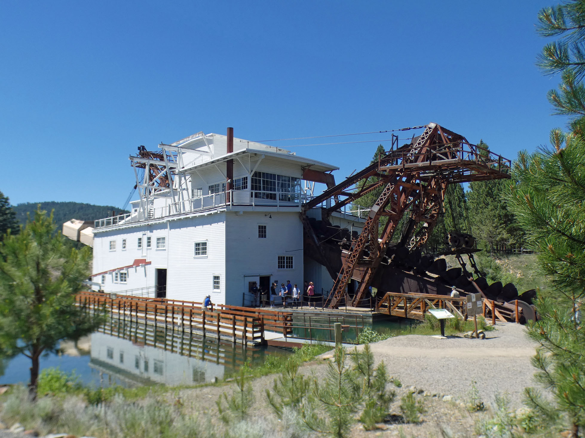
Baker City was a place where we could comfortably stay and use it as a base to explore the area.  Our first visit was to the Sumpter Dredge, about 30 miles into the mountains.  We've seen dredges before, and it always amazes us that these huge machines could move up a stream-sized river while excavating for gold.  The dredge is huge - the boom alone has 72 one-ton buckets!


The dredge was basically a big sluice box and only needed three men to operate it; however, another 17 were needed for support (maintenance, admin, etc.).  Although the dredge made $4.5 million during it's lifetime, it lost money and was shut down in 1954.  The interior was immense with all kinds of motors, belts, pulleys, and chutes going in all directions.  I have no idea how it all worked, but it must have been noisy!


We continued past the dredge along the Elkhorn Scenic Byway, a 106-mile loop that took us through the mountain gold country and back to Baker City.  It's a beautiful area of high mountains and forest:


We visited the nearly-ghost town of Granite, a gold mining town that was shut down during WWII.  The population in 1960 was one lone occupant, but it's been exploding with growth and now has a population of 40.  Most of the buildings are abandoned, but some have been partially restored and are occupied.


Throughout the area we could see mining tailings - they're everywhere along the road and well into the forest.  There are also areas that look like tailing from a dredge, but were created when hundreds of Chinese miners moved and stacked rocks to expose the water underneath.  It's difficult to visualize, but these mountain areas teemed with miners and small settlements drawn to the lure of gold.  And just as fast as they appeared, they disappeared when the gold ran out.


As we continued on the byway, the tailings disappeared as we drove into a rugged area of mountains.  We passed Anthony Lakes, a resort area with golf course and ski resort.  Overlooking the area is Gunsight Mountain, aptly named when you look at the summit.

Eventually we turned east and descended back into the valley and Baker City.  We truly enjoyed our visit to Baker City and the surrounding area, but it was time to move on.  Check back with us for Eastern Oregon, Part II!


Tuesday, June 29, 2021

Oregon's Volcano Country

 When we think of volcanos, large cones like Mount Saint Helens come to mind, so we were surprised to learn that an active volcano larger than Rhode Island was right here in Central Oregon.

The Newberry Volcano National Monument is a "shield" volcano, one that produced lava of a thin consistency and have broad sloping sides and sloping hills in a circular pattern that resemble a warrior's shield. Like Yellowstone, it doesn't seem like a volcano until you can view the caldera from above, and unlike Yellowstone, we had that opportunity from Paulina Peak.

But like Yellowstone, the volcano is active and an eruption would impact the lives of as many as 200,000 people.  The entire area is monitored and it is considered by the USGS to be a "very high threat" volcano.  Yikes!

This map clearly shows just how large the volcano in relation to the area and some of the towns and cities that could be affected by an eruption:

With two large lakes in the caldera, this is a popular area for camping and water sports.  Entering the park, we split off of the main road onto a gravel road that climbed to the overlook nearly 8000 feet up.


 From here we had a great view of the two lakes within the caldera, Paulina Lake and East Lake. 


Paulina Lake is the larger of the two with a depth of 250 feet and has produced state record Brown Trout:


From here and looking to the east, it was easy to see the caldera rim:


Looking to the west, we could see the traditional volcanic cones of the Three Sisters, still snow covered on this hot June day:

Driving back down to the caldera floor, our next stop was the Big Obsidian Flow, the newest of the area's volcanic activity at 1300 years old.  Formed by lava, Obsidian is a natural glass with no crystalline structure.  Here's a picture that show just how big the flow is:


And a close up of one of the large obsidian "black glass" rocks:


We finished our visit with a drive around the lake and a stop at Paulina Falls, just below the lake.  Above the falls the forest was green, quiet and beautiful.


We enjoyed our visit to this interesting area and were surprised that an active volcano existed here in Central Oregon.  We're moving east soon, and hope that you'll check back and see our next adventure.


Saturday, June 12, 2021

On the Road Again....Finally!


After seven long months of being stationary on the Oregon Coast, we've finally begun our summer of travel.  Our first stop after reaching the I-5 corridor was a Memorial Day's stay at the Seven Feathers RV Resort in Canyonville.  "Resort" is a word used lightly by RV park owners, but Seven Feathers truly fits that definition. 
Disneyland landscaping, beautiful shaded sites, huge indoor pool, exercise room, and manicured walking trails are all meticulously maintained.  And most important, a free shuttle to the casino! 
Visiting the casino was a shock to us - no ID check on entry for contact tracing and no mask!  Being vaccinated this wasn't a problem for us, but it was hard to believe that everyone else had received theirs, and they assured us that there had been no COVID-19 cases reported in over two weeks.  Canyonville is located in a mountainous area of the interstate, and we decided to explore the area by taking a drive east along the South Umqua River.  It was a beautiful drive through a green valley and small towns. 

Milo Academy
In the former town of Milo (now a part of Day's Creek) we came across the Milo Academy, a Seventh Day Adventist boarding school for high school students. It's an interesting place - on former ranch property, it has extensive fields, orchards, shops, and even an equestrian academy. This seemed like an unusual place for an academy -  over 16 miles from the small town of Canyonville and over 60 miles to a city of any size (Grant's 
Pass).  To enter the academy grounds, you must travel through a picturesque wooden bridge....except that it's not really wooden. 
The original bridge was, but it couldn't bear the weight of trucks that were bringing in building materials and it was replaced with a steel structure.  The locals were unhappy and wanted their wooden bridge back, so the steel was covered with wood.  It's the only one of its kind in Oregon.


Further up the road, we stopped at South Umpqua Falls, which although far off the beaten path was busy with people trying to beat the heat.  Heavily forested, the area was beautiful and the blue skies and sound of rushing water made it a great place to just sit and relax.


From Canyonville, we headed south for a week's stay at Valley of the Rogue (VOR) State Park, a very nice park along the interstate outside of Medford.  We were here to catch up on shopping, restaurants, and have the annual maintenance performed on our motor home.  On the coast we'd been complaining about the cool temperatures.  What we didn't expect was going from 50 degree weather on the coast to 104 degrees on the day we arrived at VOR. 

Our site at Valley of the Rogue

Fortunately, the park was heavily treed and we were parked in shade for most of the day.  It was time to break out the long-ago used shorts and sandals, and although the high temperatures made it sometimes uncomfortable, we enjoyed shopping at places other than Wal-Mart and Fred Meyer!  


We celebrated Brenda's birthday with a trip to Yreka, California's Rain Rock Casino for some gaming and dinner.  On the way, we passed Mt. Shasta which normally would be snow covered.  This year's appearance is another indicator of the light snowpack experienced throughout the Pacific Northwest.  

Mount Shasta June 6th

Temperatures eventually cooled down into the 60s and we packed up and drove north and east over the mountains, passing north of Crater Lake, and then down to Hwy 97 and Crescent.  

We're staying for a week at Big Pines RV Park, a nice park just of the highway.  While the pines aren't all that big, the sites are and it's a comfortable place to stay and it gives us a great location to explore the area.  

Our first trip out was to explore the Cascade Lakes Scenic Byway.  We drove west up into the Cascades to the town of Crescent Lake for a bite at the Mountain House Kitchen before driving to the shores of Crescent Lake and Odell lake.  At Crescent Lake we could see snow-covered mountains in the distance.

Crescent  Lake

At Odell Lake, another beautiful vista with Diamond Peak and a large volcanic cone in the distance:

Diamond Peak from Odell Lake

Volcanic Cone from Odell Lake

The Cascade Lakes Scenic Byway is a wonderful drive; smooth pavement with dazzling terrain and beauty - every curve reveals a new view of a distant peak or lake.  We passed blue-green Davis Lake and shortly after, a large lava flow.  This was "blocky" lava instead of the mud-like flows we're used to seeing.  It towered over the highway and seemed out of place:

Blocky Lava

Somehow this Ponderosa Pine found enough soil to gain a foothold - the only tree visible in the lava field.


Pine growing in lava bed

There were huge stands of wildfire killed trees in one long stretch of highway.  We were impressed by this stand of bleached-out pines from a fire in years past:


Coming around a curve brought Mt. Bachelor into view:

Mt. Bachelor

And finally, a view that made our day.  Suddenly coming into view was South Sister, beautiful with its covering of snow:

South Sister

We'll leave this trip report with a flashback to our winter site at Osprey Point RV Park.  Just before leaving for the year, the sunset put on this show to say goodbye:


Thanks for checking in on us - we'll be posting often as we work our way across Oregon so check back!